"I love that you've brought this to attention. An extensive database of uncommon but resistant and hardy plants/foods could be developed and organized by climate. Ease of growth and processing should also be taken in to account. I will try to…"
A crash course in changing the world.
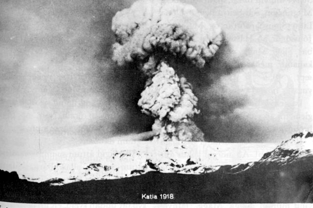
Living on the edge... of a volcano
I guess by now everyone knows about the troublesome volcano under the Eyjafjallajökull glacier. And most have heard the speculation that Katla is the next volcano to go off. If that happens, things in Iceland will be a lot more dire than now, as Katla is a notorious troublemaker in the volcano world.
In the event of the eruption, a system like Ushahidi would help greatly in the evacuation and search and rescue efforts. I'm attempting to draw a road map of the eruption.
First there would be a massive flash flood. At the peak of an eruption in 1755 the flood discharge has been estimated at 200,000–400,000 m³/s (7.1-14.1 million cu ft/sec); for comparison, the combined average
discharge of the Amazon, Mississippi, Nile, and Yangtze rivers is about 266,000 m³/s (9.4 million cu ft/sec).
The information needed here would be the location, direction and size of the flood; which roads and bridges have been destroyed or rendered impassable by the flood; which areas have been isolated and are now out of reach for terrestrial transport; which areas are the worst affected and in need of help; what are the closest safe spots for evacuation; what is the status of the rescue operations.
Volcanic ash would then start to envelop the region, depending on wind direction. This can prevent some or all aircraft from flying in the affected area and can cause illness or death in animals and humans. Useful information in this situation would be the wind direction; which areas are currently unaffected and safe to evacuate to; the location of first aid posts where people can get breathing masks; the quality and density of the ash fall; the location of the worst-affected areas; the location of the S&R teams; the status of the evacuation and rescue operations; the extent of the no-fly zone; the status of various airports and heliports in the area.
Views: 48
Comment
Latest Activity
Fourth of July on the Lake
This past weekend was the annual celebration at the lake house in Connecticut. It is amazing that the lake is still so clear and beautiful after all these years. The watershed association has done a wonderful job protecting these waters from the damaging effects of development.The wood grill was finally ready to cook on, so we didn't miss the propane tank fueled grill anymore. The food actually tasted fresher than in the past and was easy to keep fueled.Dad was very proud of the solar hybrid…See More
Stinging Nettle
In this blog post I will focus on a plant that is abundant in our nature, and which is immensely nutritious. It's of course the Stinging Nettle. Let's start with the chemical constituents of this plant:37 % Non-Nitrogen-Extracts19 - 29 % Ash9 - 21 % Fiber4 % Fat22 % ProteinOnce the leaves are drid, their protein content can reach an astounding 40 %, which is much higher than beef, which even under the best of circ**stances can never exceed 31 % protein. In addition the Stinging Nettle consists…See More
The meal
It is 7'oclock, I was late home from work due to an assignment that i wanted to get ahead on. By the time I get home I am feeling extremley tired and I cannot be bothered to make a proper meal. I walk to the fridge and open it to see what there is for me to eat. All of the out of date foodstuffs have been automaticaly thrown away by the fridge, they will be recycled tomorrow as animal feed or something. I see i have organic local eggs and some local cheese. Foods are vacc** sealded for easy…See More
Future
FutureToday is 2020/1/1. It is just like yesterday. The war is still continuing. It has started since 2010. In 2010, that year was a horrible year. Almost every energy ran out. Every country’s governments were crushed down at the same time. There were riots everywhere. All of the big company’s bosses were killed xdeadx in the riots. Troops fought each other everywhere. Food was bought up xawayx at once. There were no more food supplies in any shops. The economy was all crushed down. All the…See More
public servants
The exchange works directly for state and public workers and servants. It gives them credit in exchange for the amount of public work they contribute to the community. The more constructive they are based off a base rate the more credit they recieve.


© 2024 Created by Alchemy.
Powered by
![]()
You need to be a member of Urgent Evoke to add comments!
Join Urgent Evoke